- Jan Mayen
-
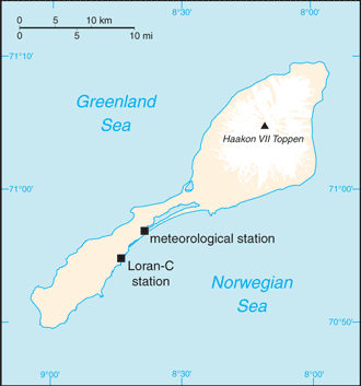 Introduction ::Jan MayenBackground:This desolate, arctic, mountainous island was named after a Dutch whaling captain who indisputably discovered it in 1614 (earlier claims are inconclusive). Visited only occasionally by seal hunters and trappers over the following centuries, the island came under Norwegian sovereignty in 1929. The long dormant Beerenberg volcano, the northernmost active volcano on earth, resumed activity in 1970 and the most recent eruption occurred in 1985.Geography ::Jan MayenLocation:Northern Europe, island between the Greenland Sea and the Norwegian Sea, northeast of IcelandGeographic coordinates:71 00 N, 8 00 WArea:total: 377 sq kmcountry comparison to the world: 205land: 377 sq kmwater: 0 sq kmArea - comparative:slightly more than twice the size of Washington, DCLand boundaries:0 kmCoastline:124.1 kmMaritime claims:territorial sea: 4 nmcontiguous zone: 10 nmexclusive economic zone: 200 nmcontinental shelf: 200 m depth or to the depth of exploitationClimate:arctic maritime with frequent storms and persistent fogTerrain:volcanic island, partly covered by glaciersElevation extremes:lowest point: Norwegian Sea 0 mhighest point: Haakon VII Toppen on Beerenberg 2,277 mnote: Beerenberg volcano has numerous peaks; the highest point on the volcano rim is named Haakon VII Toppen, after Norway's first king following the reestablishment of Norwegian independence in 1905Natural resources:noneLand use:arable land: 0%permanent crops: 0%other: 100% (2011)Irrigated land:0 sq km (2011)Natural hazards:dominated by the volcano Beerenbergvolcanism: Beerenberg (elev. 2,227 m) is Norway's only active volcano; volcanic activity resumed in 1970; the most recent eruption occurred in 1985Environment - current issues:NAGeography - note:barren volcanic island with some moss and grassPeople and Society ::Jan MayenPopulation:no indigenous inhabitantsnote: personnel operate the Long Range Navigation (Loran-C) base and the weather and coastal services radio stationGovernment ::Jan MayenCountry name:conventional long form: noneconventional short form: Jan MayenDependency status:territory of Norway; since August 1994, administered from Oslo through the county governor (fylkesmann) of Nordland; however, authority has been delegated to a station commander of the Norwegian Defense Communication ServiceLegal system:the laws of Norway, where applicable, applyFlag description:the flag of Norway is usedEconomy ::Jan MayenEconomy - overview:Jan Mayen is a volcanic island with no exploitable natural resources, although surrounding waters contain substantial fish stocks and potential untapped petroleum resources. Economic activity is limited to providing services for employees of Norway's radio and meteorological stations on the island.Communications ::Jan MayenBroadcast media:a coastal radio station has been remotely operated since 1994 (2008)Transportation ::Jan MayenAirports:1 (2013)country comparison to the world: 222Airports - with unpaved runways:total: 11,524 to 2,437 m: 1 (2013)Ports and terminals:none; offshore anchorage onlyMilitary ::Jan MayenMilitary - note:defense is the responsibility of NorwayTransnational Issues ::Jan MayenDisputes - international:none"
The World Factbook. 2014.